
Distance measurement is a fundamental concept in mathematics that quantifies the spatial separation between two points.
It plays a pivotal role in various fields, including geometry, physics, and engineering.
Understanding how to calculate distances accurately is essential for solving real-world problems, from determining the shortest path in a city's road network to optimizing the layout of components in a complex circuit.
By mastering distance measurement, you gain a versatile tool for solving a wide range of mathematical and practical challenges.
The Euclidean distance formula is a cornerstone of geometry and physics.
It calculates the straight-line distance between two points in a Cartesian coordinate system.
This distance formula, which employs the Pythagorean theorem, provides the shortest path between two points.
It is incredibly useful in applications where the concept of a "straight line" is relevant, such as measuring the crow-fly distance between two geographic locations on a map or determining the shortest distance between two cities.
The Euclidean distance formula is versatile and widely applicable in fields ranging from engineering and computer science to robotics and physics.
calculates the shortest straight-line distance between two points in a Cartesian coordinate system.
Let's illustrate this with a simple example:
Consider two points in a 2D plane: Point A at coordinates (3, 4) and Point B at coordinates (6, 8).
To find the Euclidean distance between these points, plug the coordinates into the formula:

So, the Euclidean distance between Point A and Point B is 5 units.
The Manhattan distance formula, also known as the L1 distance, is used to calculate the distance between two points in a grid-like system.
The Manhattan distance formula, also known as the L1 distance, is used to calculate the distance between two points in a grid-like system.
Unlike the Euclidean distance, which considers the shortest path between two points, the Manhattan distance measures the total distance traveled when moving from one point to another along the grid lines.
This makes it particularly useful in scenarios such as city planning, where streets often follow a grid pattern.
By summing the absolute differences between the coordinates of two points, the Manhattan distance provides an efficient way to assess distances in grid-based environments, contributing to various applications in urban planning and logistics.
Extending distance calculations to three-dimensional space is essential in fields like physics, engineering, and 3D graphics.
In three dimensions, the Euclidean distance formula incorporates a third coordinate (z) and calculates the spatial separation between two points (x1, y1, z1) and (x2, y2, z2).
This 3D distance measurement is indispensable when dealing with problems like calculating the distance between two objects in 3D space, assessing the dimensions of physical objects, or determining distances in 3D modeling and computer graphics.
Understanding how to apply the Euclidean distance formula in three dimensions enhances your ability to solve real-world problems in diverse disciplines.
Polar coordinates introduce a different way to represent points in space, using a radius (r) and an angle (θ) relative to a reference point.
To calculate the distance between two points in polar coordinates (r1, θ1) and (r2, θ2), the distance formula is derived from the law of cosines.
This formula considers both radial differences (r1 and r2) and the angular separation (θ2 - θ1) between the points.
Polar coordinates and their associated distance calculation are essential in physics, particularly in problems involving rotational motion, electromagnetic fields, and wave propagation.
This mathematical framework allows for precise distance measurements in scenarios where radial and angular information is more relevant than Cartesian coordinates.
Point A with coordinates (r1, θ1) = (4, 30 degrees) and Point B with coordinates (r2, θ2) = (5, 60 degrees).
To find the distance between these two points, we'll use the polar distance formula:

Substituting the values:

Now, calculate:
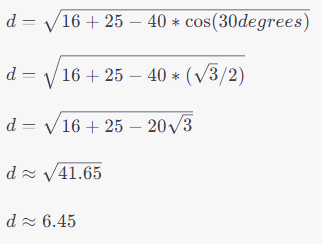
So, the distance between Point A and Point B in polar coordinates is approximately 6.45 units.
When dealing with geographic coordinates (latitude and longitude) on the Earth's surface, standard Euclidean distance calculations are not suitable due to the planet's curved shape.
Instead, the Haversine formula is employed to find the distance between two points on Earth accurately.
By accounting for the Earth's radius and the angular separation between two locations, the Haversine formula provides precise distances for navigation, geospatial analysis, and geography.
Whether you're planning a road trip or conducting research in geology, understanding how to calculate distances on Earth's surface using latitude and longitude coordinates is indispensable for making accurate measurements and decisions.

Engineers rely heavily on distance calculations in various applications.
When designing road networks, they determine the shortest path between locations to optimize transportation routes and reduce travel time.
In structural engineering, precise distance measurements ensure the integrity and stability of structures. In electronics and circuit design, understanding distances between components is crucial for efficient layouts and signal propagation.
Additionally, distance calculations play a significant role in fields like telecommunications, where signal propagation delays must be minimized.
Mastering distance calculations is essential for engineers to ensure the safety, efficiency, and effectiveness of their designs and projects across numerous industries.
Distance metrics are foundational in computer science and data analysis.
They measure the similarity or dissimilarity between data points in various contexts, from clustering and classification to recommendation systems.
The Hamming distance, for instance, quantifies the difference between two strings of equal length by counting the differing elements.
The Jaccard similarity measures the similarity between two sets by considering their intersection and union.
These distance metrics enable algorithms to make decisions based on the proximity of data points, making them crucial in fields such as machine learning, data mining, and natural language processing.
Understanding and applying distance metrics are fundamental skills for computer scientists and data analysts seeking to extract meaningful insights from data.
Distance metrics in statistics are used to quantify the dissimilarity between data points or observations.
The Mahalanobis distance, for example, considers the correlation between variables and the variances along different dimensions, making it a valuable tool for multivariate analysis and outlier detection.
Other metrics, like the Euclidean distance, are widely used in clustering algorithms to group similar data points together.
These distance metrics help statisticians and data scientists uncover patterns, identify anomalies, and make informed decisions based on the relationships within their datasets.
Understanding and applying appropriate distance metrics are critical for statistical analysis and modeling.
To reinforce your understanding of distance calculations, practical examples and exercises provide hands-on experience.
These exercises involve scenarios where you'll apply the various distance formulas discussed earlier.
For instance, you might calculate the Euclidean distance between two points in a 2D plane, find the Manhattan distance in a grid-based maze, or determine the Haversine distance between two geographical coordinates.
Solving these problems not only enhances your mathematical skills but also demonstrates the real-world applications of distance measurements in different domains.
Practicing these exercises will make you proficient in using distance calculations to solve a wide range of problems effectively.
It quantifies the space between two points.
Calculating straight-line distances.
In grid-based systems.
Extend the 2D formula with a z-coordinate.
They use radius and angle; distance uses the law of cosines.
Measuring distances on Earth's surface.
Road design, structural engineering, electronics layout.
Clustering, classification, recommendations.
A statistical metric for outliers and multivariate analysis.
Hands-on practice for real-world understanding.